
It's official: agency releases 'preferred route' for Greenway
The New York Metropolitan Transportation Council officially unveiled its plan for the Bronx portion of the Hudson River Greenway at RiverFest on Sunday.
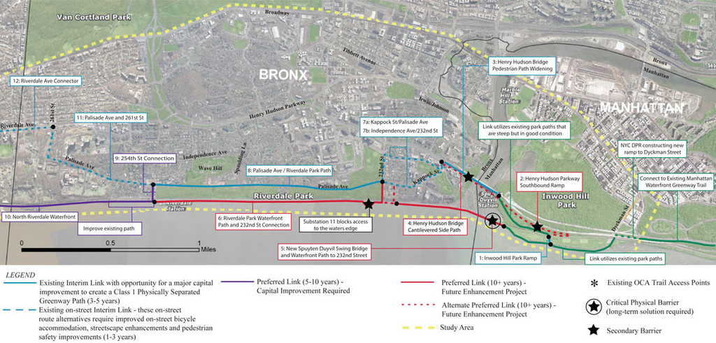
The Hudson River Greenway was established in 1991 to create a series of land and water trails from West 59th Street in Manhattan to the Hudson Crossing Park Trail in upstate Saratoga County.
Currently, the greenway, with bicycle and pedestrian trails, runs all the way from Battery Park in Manhattan to Troy, N.Y., excluding only the Bronx and part of Yonkers.
The organization unveiled the proposal for its preferred route — arrived at after many years of deliberations and input, particularly from the Friends of the Hudson River Greenway in the Bronx — to connect the path through Riverdale.
It would run from Manhattan, across the Henry Hudson Bridge and then traverse streets in Spuyten Duyvil to the riverfront. There it would bridge the Metro-North tracks and run between them and the river’s edge from West 232nd Street the Yonkers border.
In 2008, the state began planning the route and last year presented a variety of potential paths. Among the multi-million dollar plans that have been floated was one — which was not adopted — to replace the Spuyten Duyvil Swing Bridge and another to utilize the Henry Hudson Bridge, which made it to the final proposal.
The blueprint includes a cantilevered path on the side of the bridge with enough room for two-way bike and pedestrian traffic, at a cost of approximately $15 million.
Keywords
New York Metrpolitan Transportation Council, Hudson River Greenway, development


